

From its entrance at the Medd’s Mountain Park and the millpond in the village of Millbrook, the original loop of Millbrook Valley Trails (MVT) traverses a diversity of natural vegetative communities to the southern boundary of the Ministry of Natural Resource Provincial Fishing and Nature Areas, and follows Baxter Creek through forests, wetlands and meadows. Along the way, trail visitors can see historic, environmental and cultural points of interest. Foresight, planning and enthusiastic community involvement has allowed the trail system to become a key component in the local recreation landscape. How did it start?

The path along Medd’s Mountain was enjoyed by a few friends on their regular dog walks. During the 1990’s there was a growing awareness of pressure from development, but at that time the threat seemed a bit remote. Feeling the need to protect some of the natural landscape, the municipal council of the time was moving to establish an Official Plan.
In 1997, the Millbrook and District Chamber of Commerce sponsored a series of public meetings to discuss the future of the local economy and how to best utilize community resources. In May 1998, a citizen’s Steering Committee was formed, co-chaired by Cavan resident Ted Hodgkinson and then Deputy Reeve Brian Fallis to investigate the establishment of a trail. It identified a 2.5 km strip of publicly held land along Baxter Creek, running south from the pond in the village on Otonabee Conservation property and up to a section of Deyell Line owned by the Ministry of Natural Resources. Guidelines established for the project included that it be accessible, ecologically sustainable, community based and would build an awareness of local natural systems.
Volunteer groups were formed and were supported by Fleming students from the School of Natural Resources. Seed funding of $10,000 was provided by Council in 1998, with additional financial support provided by the Otonabee Conservation Foundation. In 1999, a federal grant allowed the committee to hire Ben de Waal, a Fleming College graduate, on a one year contract as Project Coordinator.
Much ground work was completed to move the project forward, including an environmental assessment and land use study. Residents with property adjacent to the proposed route were contacted in person. Support from them was universal, with the caveat that the trail be restricted to passive use with no motorized vehicle traffic allowed. Public input was sought through a series of public meetings and surveys.
By April 1999, the committee introduced a brochure and a tentative trail route at the Earth Day Celebrations which drew an audience of 150. That fall, volunteers built the first small bridge along the trail. The following month, the project received approval as a Millennium project, funding further public consultations.
The following summer, trails, bridges and boardwalks were built along the route by volunteers young and old, allowing the trail to be officially opened as a passive use nature trail in October, 2000. While the project was truly a community effort, a few residents who provided extraordinary support are recognized on a plaque located at the entrance of the Medd’s Mountain loop.
Since its inception, the trail has expanded. In 2010, a Trail Master Plan was developed for the township by Otonabee Conservation for the development of a network of trails and passive recreational properties connecting neighbourhoods, parks, schools and commercial areas while protecting the natural and cultural heritage. It sought to extend existing trails by developing linkages with existing regional trails, establish trails on unopened road allowances and establish more scenic routes for passive enjoyment.
Today there are a total of eight trail sections covering more than 13 km. The most recent addition is the Station Trail loop which connects the new subdivision bordering Fallis Line to the village core. Plans for the next phase of this development include another trail section to link these new residents as well.
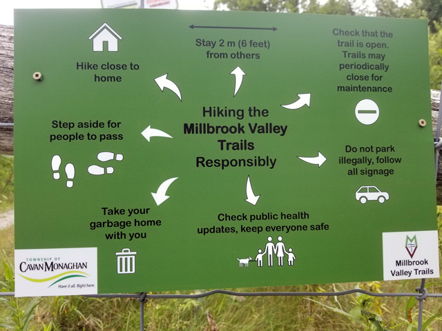
The Millbrook Valley Trails is managed jointly by the Township of Cavan Monaghan and the MVT Committee which includes a representative from the Otonabee Region Conservation Authority (ORCA), Council and community volunteers and in consultation with the Ministry of Natural Resources and Forestry (MNRF). Because most of the trail maintenance is conducted by volunteers, the annual township expenditure is minimal, with an allocation of $6,300 in the 2021 budget.
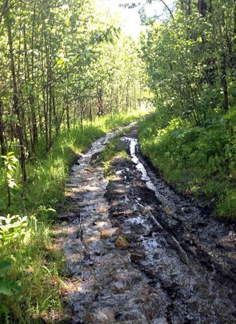
There is no winter maintenance on the trail system, and it closes every year for several weeks during the spring. This is to protect the network during the spring thaw and early rain that make the trails soft and vulnerable to damage, even from footprints. Emerging plant life is also vulnerable to traffic at this time. Stepping around muddy sections creates additional problems.
Outdoor activity is particularly welcome these days. Who couldn’t use a mood-booster? The good news is, the trails are now open, so in the words of columnist Glen Spurrell, get out and enjoy!
By Karen Graham, with notes from Ted Hodgkinson